
For such a prominent peak, Hogback inspires plenty of uncertainty. Its name is the subject of some confusion: Many visitors, and even some locals, refer to it as "Hogsback." Most maps drop the 's,' though, so we'll follow their lead. Getting to its summit isn't a sure thing, either. Unlike nearby Sugarloaf Mountain, with its wide, clearly marked single-track trail and multiple staircases on its upper slopes, Hogback forces climbers to take a series of narrow, twisty trails through woodlands, rock fields and swampy areas. With a nearly vertical rock face that demands four points of contact, the last half-mile of the climb is quite strenuous. The view is worth it, though. The rocky, nearly treeless summit offers a panoramic window on the vast, rugged forests of northern Marquette County and the endless blue expanse of Lake Superior. On the clearest days, it's just possible to see the mountains of the Keweenaw Peninsula to the northwest.
Getting to the Base
After Sugarloaf, Hogback is Marquette County's second most popular summit. Despite--or maybe because of, depending on who you ask--its popularity, it's hard to find clear directions to its summit. This is largely due to the fact that it sits in the middle of a dense trail network that makes it all too easy to take a wrong turn. Since it begins on M-550, the road that links Marquette and the small town of Big Bay, most hikers take the southern 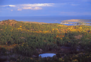 approach. From Marquette, drive three or four miles to the Wetmore Pond parking area and take the trail that starts on the northwest end of the parking lot. You'll walk through a mixed forest for a bit less than half a mile, passing through several swampy areas in the process. Stay left at the signed fork (the sign will point the way to Hogback). Eventually, you'll ascend a small hill and emerge on a broad, nearly solid expanse of granite. Walk along the bare rock, but hug the edge of the forest and follow the green blazes (visible on tree trunks and the rock surface) if at all possible. This route should take you on a gentle rightward curve and, towards the end, a moderate, sustained climb up the granite field. To the left, you'll see the rocky peak of Hogback, but don't walk towards it. Instead, continue to follow the blazes ahead and down the northern edge of the rock field. As you descend, the trail will curve to the left, straighten out, and eventually cross a snowmobile track. This track, and the stream immediately beyond it, are important landmarks.
Getting to the Top
Across the stream, you'll walk through a marshy area and enter a stand of mature hemlocks. If the blazes seem to have changed colors, don't be alarmed: They should be white or pinkish (some trees have multiple blazes) in this area. The woods here are open enough to see quite a ways ahead, and it should be clear where Hogback's slope begins. Follow the trail in this direction, stopping as you please to admire the cathedral-like canopy and impressive cliff faces on the lower slopes. If you come to a narrow, fast-moving creek, you're on the right track. At this point, it's all about endurance. The trail more or less follows the shortest distance up the hill, so be sure to take your time and pause for water breaks as necessary. About halfway up, you'll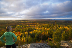 l reach the intersection of the "northern approach" trail. Stay straight/right and continue your climb, which will shortly involve some scrambling over exposed, mostly fixed rocks. Don't be afraid to use a spotter on this stretch! Fittingly, the steepest part of this climb is its final section--you'll need to scramble up a fairly smooth rock face that requires sure footing and four points of contact. Once you get past it, though, you'll be at the top. To the south, you'll see the city of Marquette and the far shoreline of Lake Superior. To the east, across the lake, it's possible to see Pictured Rocks National Lakeshore on clear days (over 40 miles away). To the north and west, the high, heavily forested ground of the Huron Mountains rises. To the north and east, Lake Superior unfolds in all its majesty. When to Go Adventurous hikers summit Hogback in every season, but midsummer is definitely the peak of the hiking season. In April and May, snowmelt and spring rains make the trail's swampy areas difficult to navigate and may slicken the mountain's rocky parts. Once the snow starts flying, it's crucial to wear seasonal footwear--snowshoes or crampons--and dress warmly. If you're in the area during the foliage season, typically early October, the view from the top is even better than usual. Even if conditions are warm, dry and sunny, you won't regret wearing sturdy hiking boots. Bottom line: Hogback is a strenuous but fun hike that rewards intrepid climbers with stunning views of Lake Superior and the southern Huron Mountains. Budget at least 90 minutes for this trek! Brian Martucci is a Marquette-based writer with a passion for food, beer, and the great outdoors. Maybe not in that order.