Hogback Mountain
So you want to climb hogback?
For such a prominent peak, Hogback inspires plenty of uncertainty. Its name is the subject of some confusion: Many visitors, and even some locals, refer to it as “Hogsback.” Most maps drop the ‘s,’ though, so we’ll follow their lead.
Getting to its summit isn’t a sure thing, either. Unlike nearby Sugarloaf Mountain, with its wide, clearly marked single-track trail and multiple staircases on its upper slopes, Hogback forces climbers to take a series of narrow, twisty trails through woodlands, rock fields and swampy areas. With a nearly vertical rock face that demands four points of contact, the last half-mile of the climb is quite strenuous.
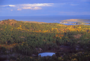
The view is worth it, though. The rocky, nearly treeless summit offers a panoramic window on the vast, rugged forests of northern Marquette County and the endless blue expanse of Lake Superior. On the clearest days, it’s just possible to see the mountains of the Keweenaw Peninsula to the northwest.
Getting to the Base
After Sugarloaf, Hogback is Marquette County’s second most popular summit. Despite–or maybe because of, depending on who you ask–its popularity, it’s hard to find clear directions to its summit. This is largely due to the fact that it sits in the middle of a dense trail network that makes it all too easy to take a wrong turn.
Since it is better marked and significantly less strenuous, most hikers take the southern approach. From Marquette, drive a few miles on County Road 550 to the Wetmore Pond parking area and take the trail that starts on the northwest end of the parking lot. Right away on the trail you’ll come to a fork, stay to the right and follow the white tree markers. You’ll walk through a mixed forest for a bit less than half a mile, passing through several swampy areas in the process. Continue following the white trail markers, and you will come to a large granite rock outcropping. There will be white painted markers across the rocks, keep following those. Very soon after you will cross a long wooden boardwalk and pass a two-track trail, continue on straight. After that, you will come to another fork, stay right again but this time you will be following the blue trail markers.
Getting to the Top
If you come to a narrow creek, you’re on the right track. At this point, it’s all about endurance. The trail more or less follows the shortest distance up the hill, so be sure to take your time and pause for wat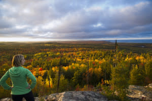 er breaks as necessary. About halfway up, there will be another fork in the trail. Stay right and go back to following the white trail markers again. After the fork, the trail will start to ascend a steep hill and you will begin making your final push to the summit. The final stretch is a difficult scramble over large boulders to reach the peak, which will require sure footing and four points of contact. Don’t be afraid to use a spotter on this stretch!
Once you get past it, though, you’ll be at the top. To the south, you’ll see the city of Marquette and the far shoreline of Lake Superior. To the east, across the lake, it’s possible to see Pictured Rocks National Lakeshore on clear days (over 40 miles away). To the north and west, the high, heavily forested ground of the Huron Mountains rises. To the north and east, Lake Superior unfolds in all its majesty.
When to Go
Adventurous hikers summit Hogback in every season, but midsummer is definitely the peak of the hiking season. In April and May, snowmelt and spring rains make the trail’s swampy areas difficult to navigate and may slicken the mountain’s rocky parts. Once the snow starts flying, it’s crucial to wear seasonal footwear–snowshoes or crampons–and dress warmly. If you’re in the area during the foliage season, typically early October, the view from the top is even better than usual. Even if conditions are warm, dry and sunny, you won’t regret wearing sturdy hiking boots.
Bottom line: Hogback is a strenuous but fun hike that rewards intrepid climbers with stunning views of Lake Superior and the southern Huron Mountains. Budget at least 90 minutes for this trek!
Brian Martucci is a Marquette-based writer with a passion for food, beer, and the great outdoors. Maybe not in that order.
ACTIVITY KEY