
Calling all history buffs and Great Lakes enthusiasts...
Spend a day soaking up Lake Superior shipwreck stories and lighthouse lore at a local museum or exploring some of Marquette's unique beacons firsthand on a guided tour.
These five Marquette County lighthouses offer breathtaking views of Lake Superior with distinctive designs and dramatic settings. Before you embark on your U.P. lighthouse adventure, here are a few fun facts about these monuments to Marquette’s maritime past.
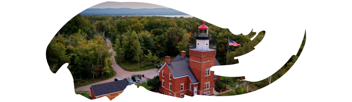
BIG BAY POINT LIGHTHOUSE
Latitude: 46.84143 Longitude: -87.6806
🚢 Stands halfway between Marquette and the Keweenaw Portage Entry.
🚢 The point occupies a position between Granite Island and Huron Islands, but the two lights are invisible to one another.
🚢 In the past, a number of vessels have been wrecked on Big Bay Point.
🚢 Today the Big Bay Point Lighthouse operates as a bed & breakfast.
HURON ISLAND LIGHTHOUSE
Latitude: 46.9633 Longitude: -87.9983
🚢 The Huron Island lighthouse is listed in the National Register of Historic Places.
🚢 Located on West Huron Island, the island is one of several that make up Huron National Wildlife Refuge.
🚢 The refuge was established by Theodore Roosevelt in 1905 and is the oldest refuge in the Great Lakes-Big River Region.
🚢 The “schoolhouse” style structure was constructed with local granite from the Huron Islands.
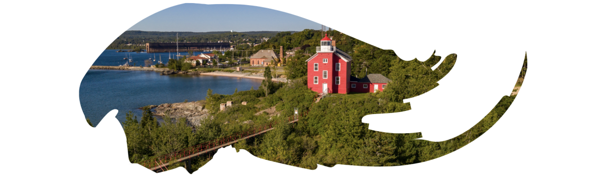
MARQUETTE HARBOR LIGHT
Latitude: 46.545433, Longitude: -87.379955
🚢 This lighthouse is one of the most historic navigation beacons on Lake Superior and was critical in the role of Great Lakes iron ore trade and assisting in safe navigations back when Marquette was the premier shipping port for iron ore.
🚢 The first Marquette Habor Light was built in the city in 1853.
🚢 The present-day lighthouse was constructed in 1866 with an additional (second) story added in 1909.
🚢 The light still shines for today’s sailors.
PRESQUE ISLE HARBOR LIGHTHOUSE
Latitude: 46.57416 Longitude: -87.37463
🚢 Also known as “Upper Harbor Lighthouse."
🚢 Located at the end of the hardy Upper Harbor Breakwall, which is open to the public (weather, conditions, and discretion dependent).
🚢 Day and night, this beacon still guides ships into the railroad ore docks.
🚢 A nearby monument serves as both a tribute and a reminder of Lake Superior’s strength.

STANNARD ROCK LIGHTHOUSE
Latitude: 47.1834 Longitude: -87.225
🚢 Deemed the “Loneliest Place in North America.”
🚢 Named after Captain Charles C. Stannard, who discovered a dangerous reef more than a mile long off of the coast of northern Marquette County in 1835.
🚢 Construction of this concrete-based beacon took five years. During 1878-79, the crew was allegedly able to work a mere 61% of the season due to storms.
🚢 Due to the awful isolation, keepers typically rotated three weeks on and one week off. The longest consecutive stay on the Rock was by Louis Wilks for 99 days.


Historic Walking Tour
This self-guided walking tour will take you through some of the most scenic and historic districts of downtown Marquette. → View... Read More

Big Bay: Henry Ford’s UP Getaway
When you visit Big Bay you will be taken aback by its natural setting with acres of forests lining expansive lakes. It’s hard to... Read More